

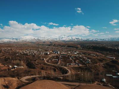
Photo:
More frequent and intense floods, mudflows, landslides, avalanches and other climate change-related disasters in Uzbekistan are putting lives and livelihoods at risk and slowing progress towards the Paris Agreement and Sustainable Development Goals.
The Green Climate Fund-financed project 'Enhancing Multi-Hazard Early Warning System to Increase Resilience of Uzbekistan Communities to Climate Change Induced Hazards' (2021-2027) responds to a critical need to modernize Uzbekistan's early warning system into an impact-based Multi-Hazard Early Warning System (MHEWS). A MHEWS will improve early warnings on floods, mudflows, landslides, avalanches and hydrological drought in the more populous and economically-important eastern mountainous regions, an essential element of the country’s climate risk management framework.
The MHEWS will serve to enhance climate resilience of 32 million people (indirect beneficiaries), including the most vulnerable and poor rural communities. The improved early warning systems will also support risk-informed planning, resilient livelihoods, good health and well-being, and food and water security.
Key achievements [August 2024]:
- 25 automated weather stations, 10 photoelectric meteorological stations and 47 specialized devices for water measurement installed and operationalized across seven regions of Uzbekistan, providing crucial data for improved forecasting.
- 450 specialists from Uzhydromet and other related ministries trained on the use of advanced weather stations and specialized devices, enhancing their ability to harness these tools for more accurate forecasting and decision-making.
- Assistance provided in equipping and operationalizing six Territorial Operational Management Centres of the Ministry of Emergency Situations, laying the groundwork for platforms that address hydrological, irrigation, flood, and avalanche risks and establishing a functional Multi-Hazard Early Warning System.
- More than 850 residents living in disaster-prone areas in Uzbekistan rained on climate risks and disaster preparedness and over 3,000 people participated in the evacuation drills organized by the project within these communities.
- Community
- District
- National
- Local Governments
- National Governments
- United Nations Development Programme (UNDP)
311 million direct beneficiaries, 2 million indirect beneficiaries
- Government of Uzbekistan
- Green Climate Fund
- United Nations Development Programme (UNDP)
Expected outcomes
Output 1: Upgraded hydro-meteorological observation network, modelling and forecasting capacities
Output 2: Establish a functional Multi-Hazard Early Warning System based on innovative impact modelling, risk analyses, effective regional communication and community awareness
Output 3: Strengthened climate services and disaster communication to end users
- Image
- Image
The Government of Uzbekistan through its Ministry of Emergency Situations (MES) implements a state program to modernize the early warning system for natural disasters[1]. This GCF project will provide the critical technical and financial resources, access to innovative technologies and expertise for the implementation and scale-up of this national initiative. The GCF-financed project will promote the transformation of climate hazard forecasting and warning from a reactive (ex-post) hazard-based system to one that is proactive (ex-ante), user-oriented and impact-based.
The project puts a strong focus on strengthening the “last mile” delivery of disaster-related communication and interaction with end users, including vulnerable communities. The improved capacity of Regional crisis management centers (RCMCs) and local communities to use and interpret climate risk information into practical early responses will directly benefit at least 11 million people (34% of total population) currently at risk from climate hazards and enhance the community resilience as a whole.
Uzhydromet’s capacity as a WMO Regional Specialized Meteorological Centre (RSMC) will be strengthened, building on the CAHM[2] (World Bank/WMO) project. The proposed GCF investment will develop automated procedures and modelling capacity that can serve as an example for other developing Central Asian countries, as well as being the driver of significant institutional change, catalysing increased efficiency in climate hazard warning generation and dissemination and developing new operational procedures between MES and Uzhydromet.
Climate change has been leading to more frequent and more intense hydrometeorological disasters in Uzbekistan and to a greater exposure to these disasters across the country. Uzbekistan sets climate change adaptation as a priority in its first Nationally Determined Contribution (NDC)[3] under the Paris Agreement. In particular, the NDC clearly highlights the need to establish a Multi-Hazard Early Warning System (MHEWS).
This project will respond to a critical need of Uzbekistan to modernize its early warning system into an impact-based MHEWS (initially focused on floods, mudflows, landslides, avalanches and hydrological drought in the more populous and economically important eastern mountainous regions), an essential element of the country’s climate risk management framework. In the face of increasing climate risks, this MHEWS will serve to enhance climate resilience of 32 million people of Uzbekistan (indirect beneficiaries), including the most vulnerable and poor rural communities living in mountainous areas currently at risk from climate-induced hazards.
Specifically, the project will improve methods and capacities for monitoring, modelling and forecasting climate hazards and risks supported with satellite-based remote sensing, create a central repository and analysis system for hydrometeorological hazard and risk information, improve regulations, coordination and institutional mechanisms for an effective impact-based MHEWS, including the development of forecast-based actions. The project will explore and facilitate the concept of forecast-based-financing (FBF) with the national institutional stakeholders responsible for disaster risk management and financing by developing SOPs and prototype decision-making systems/protocols based on the enhanced impact-based forecasting and warning. As a result, the project will significantly enhance the quality and timeliness of climate and disaster-related information available to decision-makers and the dissemination of such information to the population, as well as develop information and procedures for ex-ante actions.
The GCF grant is required to upgrade the existing hazard forecasting and warning system in Uzbekistan so it can effectively deal with the additional pressure brought about through increases in climate variability and change. This requires investments in both new observing technologies, training of technical staff, demonstration of modern approaches to hazard modelling and prediction, as well as development of awareness and educational materials and communications with communities. Together these activities will demonstrate the potential benefits of the upgraded system and contribute to the transformation of the climate and disaster risk management in the country.


Output 1: Upgraded hydro-meteorological observation network, modelling and forecasting capacities
The proposed intervention will create a more efficient monitoring network for weather, climate, hydrology and cryosphere, through both upgrading existing (automating) and installing new monitoring equipment (automatic weather stations (AWS), automatic hydrological stations, upper air sounding stations, and strategically placed low cost radars. This equipment and other existing data streams will be integrated into high availability/redundant single databases. Hazard-specific forecasting procedures will be developed and operationalized for climate-induced hazards. Training of Uzhydromet staff to undertake forecasting, operation and maintenance and data QA/QC/archiving procedures will also accompany these activities. Activities follow the GFCS and in this output are designed to address aspects related to: i) observations and monitoring; and ii) research, modelling and prediction. Uzhydromet will be the immediate beneficiary under all activities of Output 1, while their end beneficiaries include all the users of the upgraded hydro-meteorological observation network, modelling and forecasting capacities.
Activity 1.1 Upgrading and modernization of the meteorological and hydrological Observation System. This will include upgrading/automation of 25 meteorological observation stations and equipment (software, workstations etc), modernizing the ground-based infrastructure (telemetry processing, hydrogen generators etc) for 2 upper-air stations (Uzhydromet/GoU will support the establishment of 2 more), installing 2 online X-band doppler radar systems to cover current gaps in mountainous areas, upgrading and technical equipment of 90 hydrological stations , and establishing benchmarks and up to date equipment for instrument calibration (vacuum chambers, mobile laboratory etc). AWS and hydrological stations will be installed/upgraded at existing facilities and premises of key locations in the mountains above hazardous valleys and in the areas of high precipitation/landslides/mudflow risks, not already covered by investments through the CACILM and CAMP4ASB projects, as shown in Figure 46 (page 66) of the FS. Uzhydromet is strongly engaged with the WMO and maintains its standards and compatibility with existing systems. In particular it requires that goods and service comply with WMO 2003 Guidelines on Climate Observation Networks and Systems (TD No. 1185) and WMO Guide to Meteorological Instruments and Methods of Observation (the CIMO Guide No. 8, 2014 edition / 2017 update). These requirements will be taken into account during project implementation, and demonstrated compatibility with existing systems is part of any procurement (ITB/RFQ) tender documents under UNDP processes. All equipment will report data to central servers at Uzhydromet and will conform to WMO standards, including reporting to the Global Climate Observing System (GCOS), Global Basic Observing Network (GBON) and Global Telecommunication System (GTS). The project will also assist the government to identify long-term requirements and to enable budgeting and planning for the maintenance of all observing systems.
Activity 1.2 Upgrading Uzhydromet’s capacity to store, process and develop hazard products, as well as to communicate hydrometeorological data to regional divisions. This is a climate services information system (as described in GFCS) and involves the establishment of an operations centre, ICT servers and networking equipment to integrate data streams (hydrometeorological and satellite-based observations) and automate processes and analyses (including hazard forecasts). Software and processing routines will enable data and maps to be exported in common formats for sharing with partners and importing into the MES risk management system (see activity 2.1 below). A local cloud-based solution will be implemented to store and manage data that will benefit from offsite backups and easier access for the MES risk management system. Specifically this activity will: i) Integrate hydrometeorological data (from both automatic and manually operated stations) into a single database as a basis for developing products based on all available observed data. Automatically transmitted data from different providers/manufacturers will be integrated and undergo quality control/assurance within a single database in real time and will be available for interrogation via geo-visualization software. This activity will also: i) Expand the hydrological drought early warning system for Amu Darya (developed by the UNDP/AF project) to the Syr Darya and Zeravshon rivers. All historical streamflow and flood data for the two rivers will be collected and forecast models, with data ingestion and data processing routines, will be derived; ii) Develop automatic procedures for calculating avalanche risk in real time. Software and code will be developed to automatically update avalanche hazard maps based on snow accumulation from satellites (and AWS) and established procedures for estimating avalanche extent; iii) Develop code and procedures for automatically calculating mudflow risk maps based on precipitation observations and forecasts for 2-3 days lead time; iv) Develop a landslide risk model for Eastern Uzbekistan based on geophysical and geotechnical characteristics, including subsurface water and extreme rainfall. The skill of all developed forecast systems will be assessed using retroactive forecasts and used to assess their utility for forecast based actions in activity 2.1 and 2.2.
Activity 1.3 Re-training and advanced training of Uzhydromet staff on monitoring and forecasting technologies and procedures (training of MES staff is covered in output 2 below). International experts will train weather forecasters to work with new products of the KOSMO model (with a resolution of 13 km and 2 km). Refresher courses and advanced training will be provided for new software and equipment, including the introduction of new methods for the analysis and prediction of hydrometeorologically important variables and climate hazards. The project will facilitate organization of on-the-job trainings, engagement with universities, courses and seminars with the involvement of foreign specialists. Training of IT specialists of Uzhydromet will be conducted for work with the computer center and operation of the KOSMO model, the UNIMAS, MITRA information reception and transmission system, workstation software (for weather forecasters, agrometeorologists, GIS-METEO, etc.) and EU Copernicus programme on satellite data, all of which will be used for impact-based forecasting where needed. Trainings on AWS installation, general user training and technical support will be provided. These increased capacities will also assist Uzhydromet in fulfilling its regional role as a WMO RMSC, in accordance with the GFCS capacity development, and help improve their capacity for regional cooperation.
Output 2: Establish a functional Multi-Hazard Early Warning System based on innovative impact modelling, risk analyses, effective regional communication and community awareness
The proposed intervention will integrate and develop ICT systems to use the hydro-meteorological hazards predicted in output 1, and combine these with vulnerability data to identify risks and provide information for planning and mitigating their impacts. It will improve the efficiency of the current early warning system by automating the sharing and production of risk-related data, as well as the communication of warnings. The project will also develop methodologies for and support hazard and risk mapping and risk zoning for key climate-induced hazards (floods, landslides, mudflows, droughts and avalanche). Specifically it will introduce an advanced, impact-based information management system for combining data on socio-economics (population, livelihoods, poverty indicators), infrastructure (roads, utilities, buildings, bridges etc) and the natural environment (landcover, vegetation, soils etc) in order to operationally assess the risks associated with each hazard forecast. This information will be transmitted and shared with RCMCs in key hazard-prone districts in Uzbekistan so that regional teams have the most up to date information available for planning their operations. Building on the existing mobile-based public dissemination platforms, the project will develop geographically specific risk based warnings tailored to the areas affected by each hazard (e.g. mudflows, avalanches, landslides and flooding). Based on the user interaction guideline of GFCS, inputs from consulations with key stakeholders and end-users (activities 3.1 and 3.3) will inform the design and dissemination of warnings and alerts to communities at risk. MES and its RCMCs will be the immediate beneficiaries under all activities of Output 2, while their end beneficiaries include all the users of the Multi-Hazard Early Warning System.
Activity 2.1 Developing and installing a modernised and efficient system for assessing climate risks based on dynamic information on both hazards and vulnerabilities, including socio-economic risk models for decision making and prioritization of resilience building long-term/future investments. This would enable establishing an impact-based MHEWS, where hazard forecasting is linked to the risk and exposure information (socio-economic risk model). This involves installing both hardware and software to enable an advanced, impact-based information management system to be built, which will combine data on current vulnerabilities (e.g. indicators of poverty, education, health, housing etc), public and private assets (including infrastructure, roads, railways, housing, mines, airports, hospitals, schools etc), the environment (crops, lakes, rivers, tourism areas etc) and hazard impacts (input from Output 1) to operationally assess the risks associated with each hazard forecast. Based on evaluated risks and the skill of each impact-based forecast, a set of feasible ex-ante actions will be identified for different lead times. This activity will also develop software and standard operating procedures to automatically ingest hydrological and meteorological observations, weather and seasonal forecasts, and derived drought/avalanche/mudflow/landslide forecasts from Uzhydromet (through activity 1.2) into the system to be combined with available vulnerability data. Traning to MES staff will be delivered on risk assessment, operations and maintenance of the systems. The system will also import long-term climate change scenarios to be used for forward planning and evaluation of future risks.
Activity 2.2 Developing and introducing technical guidance, institutional and coordination frameworks to increase the efficiency of: i) data collection and archiving (activities 1.1 and 1.2); ii) hazard mapping and modelling (activity 1.2); iii) risk assessment (activity 2.1); iv) impact-based warning and forecast-based actions (activity 3.2); and v) dissemination of information to RCMCs (activity 2.3). These protocols are also required to ensure that new climate information sources (e.g. AWS, AWLS, radar and satellite observations – activity 1.1) are translated into products that are useful for decision making and investment by MES and Uzhydromet (based on feedback obtained through activities 3.1 and 3.3). Thus, under this activity the project will explore and facilitate promotion of forecast-based-financing (FBF) by developing draft SOPs and prototype FBF protocols/decision-making systems. This activity will include development of SOPs (both for ingesting and sharing data, as well as for forecast based actions to be undertaken when specific risk-related triggers/thresholds are reached), a national to regional EWS protocol, and communication protocols to accompany introduction of the new technologies. Guidance and procedures will be developed to support the application of socio-economic risk models and enhanced risk zoning in development planning and decision-making (activity 2.1). Corresponding training to MES staff will be delivered.
Activity 2.3 Designing and implementing a system for information dissemination to RCMCs and area specific mobile alerts including an information visualization system for RCMCs with software. This involves setting up information visualisation and analysis systems (video walls, telecommunication systems, servers and ICT storage) at 7 RCMS, to enable them to visualise the maps and impact forecast information provided through the risk analysis and warning system (activity 2.1) and combine it with local (regionally available) information on current vulnerabilities and field-based information. This will enable them to better target advice and direct regional response teams. This activity will further develop (improving the existing MES dissemination system) area-specific mobile and SMS based warnings for mudflows, avalanches, landslides and flooding. This will reduce the chance of false alarms sent to those not at risk, as well as improve the content based on information from the improved MES risk and impact-based forecast system (activity 2.1 and 2.2). Inputs from consulations with key stakeholders and end-users (activities 3.1 and 3.3) will be used to design the dissemination system, following the co-design and co-production user interaction guideline of GFCS.
Output 3: Strengthened climate services and disaster communication to end users
The proposed intervention will strengthen the effectiveness of delivering climate information services and disaster warnings to users in Uzbekistan at two levels. On the overall national level, the project will initiate the establishment of the National Framework of Climate Services as a mechanism to systematically bring together producers and users of hydrometeorological and climate information and to ensure that information and services reach their end recipients both in the various sectors of the government and the society and at the different geographic levels down to local communities. Disaster-related information and services being the specific focus of the project, it will work with the various public and private stakeholders to reorient the existing financial / economic model behind the provision of such services to make it more cost-efficient and sustainable in the long-term, i.a. using private investment and partnership opportunities on the domestic and the international markets. Finally, on the warning dissemination and communication aspect, updated communication technolgoies will be utilised to support real-time risk evaluation by Regional disaster managemen agencies (RCMCs) and first responders and ensure ‘last-mile’ delivery of early warning risk information to the communities at risk and population at large. In collaboration with Red Crescent Society and other community-level NGOs, RCMC will organize trainings and annual community forums to help communities at risk better interpret, understand and react to those warnings, as well as facilitate forecast-based actions and responses. Uzhydromet (and, in the long run, other parts of the Government of Uzbekistan, as well as other providers and users of climate services) will be the beneficiaries under Activity 3.1, as the NFCS provides a platform where the various service providers and end-users are engaged in the co-designing, testing and co-production to improve the content and delivery of products and services. Uzhydromet and MES (and Uzbekistan’s Government in the long run) will be the beneficiaries of Activity 3.2, as the development and promotion of a sustainable business model for disaster-related information and services in Uzbekistan will provide additional operational funding to the two institutions which currently to a large extent rely on government budgets. MES and its RCMCs as well as the communities in the 15 targeted districts as well as Uzbekistan’s population at large will be the beneficiaries under Activity 3.3.
Activity 3.1 Establishing National Framework for Climate Services for Uzbekistan
The Global Framework for Climate Services (GFCS), promoted and facilitated by the World Meteorological Organization in cooperation with GFCS partner organisations, is a framework that envisions better risk management and more efficient adaptation to climate variability and change through improvements in the quality, delivery and use of climate-related information in planning, policy and practice. GFCS, i.a. endorsed by the GCF Climate Services Strategy, focuses on developing and delivering information services in agriculture and food security, disaster risk reduction, energy, health and water, and organises its work around observations and monitoring; climate services information systems; research, modelling and pre- diction; user interface platforms; and capacity development. A strong focus of GFCS is on a multi-stakeholder approach to the definition and the actual delivery of services, thus bringing users and co-producers of climate and hydrometeorological information together and to the centre of the design and production process as opposed to more traditional supply-driven approaches. The establishment of the NFCS would typically involve:
i) an assessment of gaps, needs and user perspectives (i.a. through interviews) with respect to the current and desirable climate services;
ii) based on this assessment, the drafting of NFCS Uzbekistan concept and action plan;
iii) extensive consultations regarding the concept with the various sectors, users and co-producers of climate services; and
iv) reaching a broad agreement and Governmental endorsement for NFCS implementation.
Following an accepted WMO blueprint for the conceptualising and establishment of a NFCS, the project will undertake a baseline assessment of climate services in Uzbekistan, followed by multi-stakeholder consultations and the participatory development of the country's NFCS concept and Action Plan to be endorsed both by stakeholders and at the high executive level, ready for implementation once supplementary NFCS-earmarked funds become available as a follow-up to the project.
As part of this activity, a platform will be set up to engage end users in the design and testing of new disaster-related climate information services and products. Similarly, a National Climate Outlook Forum will be established and supported as one mechanism to help shape and deliver climate services with longer time horizon, i.a. with a particular focus on disasters such as hydrological droughts. A connection will then established between the Forum and WMO’s Regional Climate Fora operating in Europe (NEACOF) as well as Asia (FOCRAII). Both the NFCS user dialogue platform and the National Climate Outlook Forum will (as well as the NFCS process at large) will be managed by Uzhydromet.
Activity 3.2 Designing sustainable business model for disaster-related information and services
While it may not be realistic to expect any significant level of private financing during project implementation given the existing public service management model and the time required for transition, there is long-term potential for private sector investment in climate information services and for expanded service provision to private sector based on enhanced hydrometeorological and climate information in Uzbekistan, including those related to natural disasters and early warning. Linked to the NFCS process above, the project will conduct a comprehensive analysis and discussion of long-term sustainable financing options for disaster-related services in Uzbekistan beyond current state-funding model, in particular drawing on blended finance through dedicated national funds and public-private partnership opportunities. This will include seeking financing, from both public and private sources, for forecast based (ex-ante) actions identified in activities 2.1 and 2.2. Based on the analysis and consultations, a sustainable value chain-based business model for disaster-related information will be developed and agreed with the key stakeholders, and the necessary legal and organisation changes will be outlined and planned on the national (adjustment of legislation) and the inter-institutional levels (Uzhydromet, Ministry of Emergency Situations, users of the services, private investors).
Activity 3.3 Strengthening disaster warning dissemination and communication with end users
The project will significantly strengthen interaction with the end users with the aim to communicate and facilitate proactive responses to disaster information and warnings in Uzbekistan. Within the 15 RCMCs, outdoor communication boards[1] will be set up in identified communities at highest risk to alert and inform the population in real time about threats or emergencies, following which, through cooperation between MES RCMCs and the Red Crescent Society, communities will be trained to interpret and use information on climate hazards and early warnings. Printed visual information (leaflets) will be provided to RCMCs and Uzbekistan’s communities on climate hazards and associated early warnings. With expected increase of user interaction level, regional staff of MES RCMCs will be further trained in the effective use of this information to suppport community interactions (crowd sourcing and survey data) and formulate forecast-based actions following the guidelines developed in Activity 2.2. Similarly, easy-to-understand and visual information will be channelled to mass media through existing agreements between them and MES / Uzhydromet, as well as to national NGOs. Finally, this activity will also complement the prior Activity 2.3 in the development of region-specific (as opposed to the currently used national-wide) broadcasting of early warnings, with the use of other modern communication channels such as social media and electronic messenger subscription groups. In addition, the project will establish a platform for organizing annual community forums on community-based EWS engaging target communities and representatives of vulnerable groups to exchange information, lessons learned, successes and opportunities. Through such platforms regular competitions will be organized engaging both youth and the most active community representative to advocate for structural and non-structure mesures and ensure their inclusiveness.
[1] These are physical boards used to relay warnings and messages, to be installed/set up by MES in targeted districts (including in hazard-prone areas with limited mobile receptions or not immediately reachable by a Regional Crisis Management Center). Boards will be installed in popular public places used by communities or on regular commuter transport routes.
- UNDPBenjamin LarroquetteRegional Technical Advisor, climate Change Adaptation