Aerial view of Funafuti Atoll, capital of Tuvalu. Photo: Aurélia Rusek/UNDP
Funafuti, 24 July 2023 – In collaboration with the Pacific Community (SPC), the Tuvalu Coastal Adaptation Project (TCAP) has handed over to Government of Tuvalu a state-of-the-art online platform which, for the first time, allows the atoll nation to clearly identify, plan for, and reduce risks associated with sea level rise and more frequent intense storms driven by climate change. The free, publicly available platform enables the government, communities and other users to make sound, risk-informed development decisions including where to build, as well as provides a crucial tool to plan adaptation into the future.
Land is an extremely precious resource for an atoll nation like Tuvalu, which has only approximately 25 square kilometres in total across its nine atolls, much of it less than one metre above spring tide levels. The islands are seldom more than a few hundred metres across, often far less. Understanding how shorelines are changing, and the risks of inundation, is crucial to the country’s climate change adaptation response.
Comprising several tools in one dashboard, the platform covers all nine of Tuvalu’s atolls and islands. It includes inundation modelling due to sea level rise and storm waves, shoreline change detection and monitoring, damage and loss, and tools to identify marine hazards exposure.
“We warmly welcome this new platform,” said Faatasi Malologa, Director of Lands and Survey. “It is a powerful tool which fundamentally improves our understanding of coastal hazards, helping to inform our development planning and how we adapt to climate change into the future.”
“The climate crisis is on Tuvalu’s and other Pacific island countries’ doorsteps,” said a.i. UNDP Resident Representative, Yemesrach Workie. “We are thrilled to see this new platform – developed with the Pacific Community, under the UNDP and Green Climate Fund-backed Tuvalu Coastal Adaptation Project – supporting the Tuvaluan government with the evidence-base needed to plan their adaptation response.”
The shoreline monitoring tool shows change over time and reveals that while Tuvalu’s islands are dynamic – continuously shifting according to weather and climate conditions, storms, and human activities – the great concern is that the combination of sea level rise, changes to storm frequency and intensity, and degradation of living fringing reefs (bleaching and acidification) may lead to many shores becoming more vulnerable to erosion.
The only way to detect such negative trends over time is to monitor — the newly launched platform provides that capacity, nationwide.
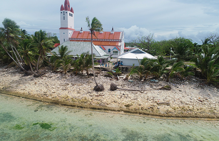
Aerial view, church, Nanumea island, Tuvalu. One of the key goals of the Tuvalu Coastal Adaptation Project is to reduce the vulnerability of key infrastructure to inundation. Credit TCAP/UNDP
“SPC’s modelling capacity in relation to coastal environments is among the world’s best. It has been fantastic to work with them in delivering this important, state-of-the-art work for Tuvalu,” said UNDP Coastal Adaptation Specialist and Chief Technical Advisor to TCAP, Arthur Webb. “You simply cannot design sound, risk-informed climate change adaptation solutions and long-term strategies without this type of information. This platform provides the required foundation.”
Crucial to SPC’s development of the platform has been the acquisition of the national Lidar baseline survey completed under TCAP in 2019. In addition, the platform incorporates tens of thousands of storm wave simulations generated through variables such as storm size + storm direction + tide + storm surge + sea level. This allows users to also look at a location’s inundation risk in relation to a storm threatening landfall.
Actual storm wave inundation modelling on Tuvalu’s islands is very complex because shores in Tuvalu are ringed by living reef platforms and fringes. To help understand inundation potential in these unique environments, physical modelling was conducted at the University of New South Wales, Manly Hydraulics Laboratory, Australia. In these experiments, scale models of some islands were accurately reproduced with scaled waves generated to show true wave impacts. The results were used to calibrate and train the subsequent computer simulations, and also to guide TCAP’s adaptation designs for Nanumea and Nanumaga.
“With the finalisation of this platform by the Pacific Community under TCAP, Tuvalu now has a world-class, comprehensive coastal hazards platform which can provide information on shoreline change over time, the changing relationship between sea level and land elevation across every island, and potential storm wave inundation patterns,” said Alan Resture, TCAP Project Manager. “We believe it is the first freely available national, high-resolution coastal hazard assessment tool for an atoll country in the world. Up until now, Tuvalu has had very limited data with which to make sound, risk-informed decisions about where to build and how to plan our response to climate change impacts. This changes everything.”
With a few clicks, anyone can now zoom into a specific location on high resolution aerial imagery of any island in Tuvalu and investigate varying scenarios of potential inundation. Expert users are also able to access data sets and refer to a detailed methods guide which explains the data, assumptions, and methods underlying the modelling.
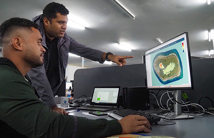
Sapolu Tetoa, Minerals Officer from the Tuvalu Lands and Survey Department (seated) and Tomasi Sovea, Senior Technical Officer at SPC (standing) examine an output from the platform developed by SPC and TCAP (2023). Credit: Merana Kitione/SPC
“This coastal hazard and risk dashboard, developed in partnership with UNDP and the Government of Tuvalu, leverages a decade of coastal hazard modelling work at SPC,” said Herve Damlamian, Team Leader for Ocean Prediction and Monitoring at SPC. “It is also part of a larger programme of work supporting Tuvalu’s increased early warning capacity, and institutional capacity to make risk-informed decisions, which directly contributes towards the fulfilment of Tuvalu’s development strategy, ‘Te-Kete’.”
The platform is expected to be used by a large range of decision-makers and government departments, development agencies and their projects as well as NGOs and even buyers of private property.
An example of use might be in the placement of important new community infrastructure such as a school. By viewing the location using the platform, designers and decision makers can see if it is subject to erosion over time, or if the land is very low lying and likely to be inundated during high water events. Likewise, the platform can show the risks associated with storm wave impacts.
Data generated by the platform is also a key piece of the puzzle in developing storm early warning systems, providing important information about which islands may suffer wave damage and flooding, and thus allowing communities to prepare and potentially move important assets and property to safer locations.
In fact, the tools and models developed under the Tuvalu Coastal Adaptation Project were leveraged by the SPC team and the Tuvalu Meteorological Service in developing a 7-day operational inundation forecast system for all communities nationwide (completed under the WMO-led Climate Risk and Early Warning System Initiative, or CREWS).
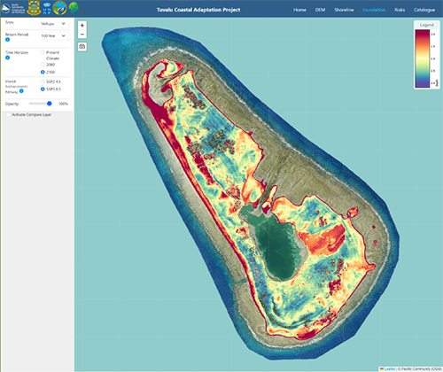
Dashboard output showing modelled wave inundation on Tuvalu’s largest atoll, Vaitupu, under a 2100, SSP5 8.5 1-in-100 year storm event (*Key in top right-hand corner for depth, with red showing areas projected to be underwater). This extent of saltwater flooding would critically damage freshwater ecosystems with dire implications for food and water security, as well as community infrastructure.
Special effort has been made to ensure the platform is easy to use and will integrate seamlessly with SPC’s national training programme under TCAP, being rolled out throughout 2023 with the view of building government capacity in coastal resilience and adaptation and incorporating feedback from users into the platform.
In the coming months, potential users across government departments will be trained in general use of the dashboard. Selected government users with GIS capacity, including staff at the Department of Lands and Survey, will also be trained in how to add data layers to the shoreline monitoring component of the system, to track change over time.
The platform is now freely accessible online at https://opm.gem.spc.int/tcap/home
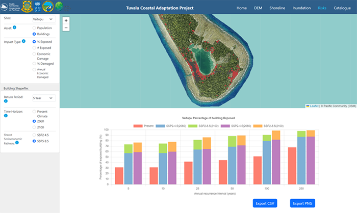
Dashboard output showing percentage of exposed buildings on Vaitupu atoll, as under 2060 worst-case emissions scenario (SSP5 8.5). The combination of sea level rise and intense storms under such a scenario would place enormous pressure on ecosystems and development.
*********************************
About the Tuvalu Coastal Adaptation Project
With US$36 million financing from the Green Climate Fund and US$2.9 million co-financing from the Government of Tuvalu, the 7-year Tuvalu Coastal Adaptation Project is contributing to strengthening the resilience of one of the world’s most vulnerable countries to climate change and sea-level rise. Implemented by the UN Development Programme in partnership with the Government, the project is improving coastal protection in key locations on the islands of Funafuti, Nanumea and Nanumaga. While new measures will act as a buffer during storms, the project also strives to build the capacity of national and island governments and local communities in adapting to climate change in the longer term. Learn more at TCAP.tv
About the United Nations Development Programme
UNDP is the leading United Nations organisation fighting to end the injustice of poverty, inequality, and climate change. Working with our broad network of experts and partners in 170 countries, we help nations to build integrated, lasting solutions for people and planet. Learn more at undp.org
About the Pacific Community (SPC)
The Pacific Community (SPC) is the principal scientific and technical organisation in the Pacific region, proudly supporting development since 1947. It is an international development organisation owned and governed by 27 country and territory members.
SPC is a key project partner to TCAP, undertaking Environmental and Social Impact, Geotechnical, Sea Level Measurement and Wave Inundation Assessments in support of TCAP’s work programme. SPC will also deliver a hands-on training programme for Tuvalu government officers and other interested parties in 2023. Among various subjects the training will cover use and improvement of the hazards dashboard.
Dr Arthur Webb | Coastal Adaptation Specialist, UNDP| arthur.webbb@undp.org