
Photo:
The main project objective is reducing the vulnerability of communities and productive ecosystems in the Municipality of San Francisco Menendez to drought risk, soil erosion, and flash floods due to climate change and climate variability. The project will integrate forest landscape restoration as a climate change adaptation strategy targeted towards increasing forest cover, improving the hydrological cycle, increasing the amount of available water, and regulating surface and groundwater flows, while maintaining and improving water supply and quality. The project landscape approach will ensure that land degradation is reduced (or reversed) and that productivity is maintained and made resilient to climate change impact, thus contributing to better food security and community resilience. By ensuring and enabling institutional and governance environment, the project will generate coordinated and informed actors with the capacity to address appropriate adaptation measures in the medium and long term thus resulting in a genuine local resilience to climate change.
The project will meet its objective by restoring 3,865Ha of forest landscape within San Francisco Menendez, through a landscape-based ecosystem intervention that will focus on the restoration of critical landscapes and enhance its capacity to manage droughts, soil erosion and flash floods; promoting and implementing climate resilient and economically viable productive alternatives in the region that address the economic vulnerability being faced in the region as traditional agricultural systems have become less productive due to climate change; generating climate and hydrological information products in the region to identify and monitor the impact of climate change in the landscape and also the effectiveness of ecosystem based interventions in their management to improve local and national responses; and enhancing local capacity to take concerted action in addressing climate change impact, prioritizing adaptation interventions and mobilizing the financing necessary for their implementation.
- Community
- Municipality
- District
- Country Office
- Local Governments
- National Governments
- United Nations Development Programme (UNDP)
- Government of El Salvador
- Adaptation Fund
- United Nations Development Programme (UNDP)
Expected outcomes
Component 1. Ecosystem-based adaptation for enhanced resilience at a territorial level
Component 2. Alternative and adapted livelihoods identified and made viable for resilient livelihoods
Component 3. Regional Climate and Hydrological Monitoring for Enhanced Adaptation Planning
Component 4. Strengthening of inter-institutional coordination and local governance for landscape management in the face of climate variability and change
- Image
- Image
- Image
National Background
- El Salvador has been identified by the International Panel on Climate Change (IPCC) as one of the countries with the highest sensitivity to climate change[1]. According to the Fifth Assessment Report of the IPCC, the country is characterized by a high exposure to geoclimatic threats, resulting from its location and topography, exacerbating climate change induced risk and vulnerability of human settlements and ecosystems[2]. The Global Climate Risk Index for the period between 1997 to 2016, covering both human and economic impacts, ranks El Salvador 16th in the world, emphasizing the country’s high vulnerability to extreme climate events[3]. There is ample evidence of climate change and variability affecting all sectors of society and economy, at different spatial and temporal scales, from intra-seasonal to long-term variability as a result of large-scale cyclical phenomena[4]. A study from The Economic Commission for Latin America and the Caribbean (ECLAC) found that between 1980 to 2008, an average of 1.5 natural disasters per year resulted in nearly 7,000 human casualties, affecting 2.9 million people, and costing US $470 million to the central government (amount that is equivalent to 4.2% of the Gross Domestic Product). The country of El Salvador spends an equivalent to 1.1% of its total GDP with dealing with climate change related impacts and infrastructure every year on average.
- El Salvador is the most densely populated country in Central America (342 people per km²) with a population of approximately 6.46 million inhabitants, of which 52.9% are women[5]. The country’s territory totals 21,040 km², with a rugged topography (50% of total land mass has slopes of over 15%), highly erodible soils and the lowest per capita availability of freshwater in Central America5. According to the measurement of compound poverty[6], 35.2% of the total Salvadoran households are poor, equivalent to 606,000 homes to approximately 2.6 million people. Similarly, the multidimensional poverty rate in rural areas is 58.5%, and 22.5% in urban areas. Thirty-eight percent of the country’s population resides in rural or non-urban areas, of which 20% are women[7]. In all the departments, other than one, over 50% of rural households are multidimensionally poor and as such are more vulnerable to the effects of climate change (Figure 1). Homes with this condition have the following deprivations: 37% food insecurity; 49% lack of access to drinking water; 83.7% no access to public health.
- Sixty percent of the national territory is devoted to agriculture, which is the main source of livelihood for the rural population in the country. About 36% of the total country territory is arable land, with corn as the main subsistence crop, followed by rice, beans, oilseeds, and sorghum, and with the cultivation of coffee and sugar cane as major cash crops The effects of climate change, as observed over recent years, have directly affected the productivity across the whole spectrum of the agricultural sector, with significant impacts on smallholder farming[8]. According to the last agricultural census, there are more than 325,000 producers of basic grains who work in land parcels of sizes ranging between 0.7-3 hectares. Not surprisingly, 52.4% of the farmers organize their agricultural activity in parcels averaging 0.7 hectares, with an average corn production of 1.427 kg/ha. This production may satisfy the immediate needs of a family household (requiring only 1,300 kg of corn per year), but is significantly lower than the national average production (2,575 kg/ha). Impact from extreme weather such as the tropical storm Mitch (1998) caused damages and total loss of US $388.1 million, with US $158.3 million (40.8% of the total) impacting the agricultural sector. The 2001, drought reported damages and loss for US $31.4 million and 81% for the farming industry. Hurricane Stan (2005) caused US $355.6 million in damages and loss, US $48.7 million and 13.7% of the total for the agricultural sector. The Tropical Depression Twelve-E (DT 12-E) in 2011 carried a price tag of US $306 million in damages and losses in the agricultural sector. Between 2014 and 2015, losses in agriculture, as a result of severe drought, costed the country more than US $140 million, with greater impact felt on subsistence crops (corn and beans), as well as in the dairy industry which lost more than 10% of its production. The sustained dry spell followed by high temperatures, has also caused severe damage to the health of human populations, to the broader agricultural sector, and the natural environment. Furthermore, the reduction or deficiency in rainfall over the period has also affected the availability and quality of superficial and underground water resources.
Extreme weather hazards and climate change in El Salvador
- El Salvador is currently impacted by the effects of climate variability and change, with highly variable rainfall patterns, both spatial and temporal, which is leading to an increase in the number of extreme climatic events (i.e. tropical cyclones, floods and droughts). Over time, El Salvador has passed from experiencing one event per decade in the sixties and seventies, two in the eighties, four in the nineties, to eight extreme events in the last decade. This shows a shift from previous decades, when extreme events hitting the country would originate mostly from the Atlantic Ocean, and had its first wave of impacts mitigated by the land mass of neighbouring countries. This is no longer the case, since the frequency and intensity of tropical cyclones originating from both the Atlantic and the Pacific Oceans has increased over the past two decades.
- Studies from the National Service of Territorial Studies (Servicio Nacional de Estudios Territoriales, SNET) reveal that at least 10% of the country is prone to floods, 20% percent is exposed to landslides, 50% is affected by drought. The poorest segments of the population are particularly hit by natural disasters, as they are more likely to live in hazardous parts of the territory, such as flood plains, river banks, steep slopes, and fragile buildings in densely populated zones.
- In 2014, the average accumulated rain for July ended as the lowest in the last 44 years[9] on record, and in 2015 the average accumulated rain during the rainy season was the lowest ever recorded, reaching only 63% of what should be expected given normal historic climate conditions (Figure 4). Extended drought periods in the country, have traditionally been followed by high temperatures, hindering progress and functioning of important sectors of the economy, including agriculture, health, water resources, and energy. According to the Food & Agriculture Organization of the United Nations (FAO), approximations from Central America’s main the prima harvest for 2015 showed a decline of 60% in the total maize harvest, and 80% in the total beans harvest due to drier than normal weather conditions.
- Consecutive dry years, in which the dry spells last for extended periods of time, have become more frequent due to climate change. This has had wide spread effect across different sectors, consequently increasing risk and vulnerability of populations in El Salvador. Most importantly, this causes reduction on the availability of food (also affecting its access and use), due to impacts on income and basic goods availability in certain regions of the country, with serious social and economic impacts in the long-term. Furthermore, extended drought periods in the region has made landscapes more susceptible to soil erosion, floods and landslides, especially in the advent of localized rainfall in excess. Droughts in El Salvador are also known for causing fluctuations in food prices, plant pests epidemic, animal disease propagation, financial and political instability.
National Climate Scenarios
- The climate change scenarios indicate that in the coming years, El Salvador will experience more intense, and more frequent, extreme events. According to the projected scenarios, the country will consistently face reductions in precipitation and constant increases in temperature (Figure 5). The National Climate Scenarios produced by the Ministry of Environment and Natural Resources (MARN) show that over the course of this century, the average temperatures (maximum and minimum averages) will increase considerably, with the magnitude of the change being most marked for the period 2071-2100.
- Average and minimum temperature will shift considerably between the periods 2021-2050 and 2071-2100 under all climatic scenarios. This represent changes between 1 °C and 3 °C and up to 4.5 °C towards the end of the century. These projected changes in temperature for El Salvador, are most in line with the changes projected by the IPCC. Temperature increases of such magnitude, will have direct effect on the temperature of the Pacific coast. When breaking and zooming into the time series of projections, the data shows that, in the near future (between 2021-2030 and 2031-2041), all scenarios point out to shifts between 0.7 °C and 1.5 °C, which is higher than what its observed today. The last decade in the period under consideration, presents the greatest changes in temperature with values between 1.5 °C and 2 °C in the country. These projections reveal that, in the future, 90% of the national territory will be subject to average temperature values above 27 °C.
- All scenarios point to a decrease in precipitation between 10% to 20%, across the country between 2021-2050, with some regions being expected to see a reduction above 20% (under a high emissions scenario). This would represent a reduction of no less than 200 mm per year in precipitation. Comparably, towards 2041-2050 the magnitude of rainfall reduction will remain on the mark between 10% to 20%, similar to the previous period. It is worth noting that projected changes between 2031-2040 can be attributed to already ongoing climate change and variability processes in El Salvador, and that these changes are within the scope of the IPCC projections for the region.
- The projected scenarios for the period between 2071-2100, show even more drastic changes in precipitation patterns in the country, with values ranging between 20 to 26% under the high emissions pathway. When looking at each decade in detail, for example, between 2071-2080 the changes represent a decrease of 15-25% in rainfall, under a low emissions scenario, followed by 20-25% reduction in rainfall under a high emissions scenario. By the same token, the decade of 2081-2090 will experience reductions between 20% to 30%, with even higher depletion of rainfall under the high emissions scenario. During the last decade of the 21st century between 2091-2100, the projected scenarios reveal a decrease in rainfall ranging between 20% -35% (low emissions scenario) when compared to current observed values. At the century approaches end, the scenarios reveal reduction in precipitation that are considerably more pronounced, intense and drastic if compared to the period between 2021-2050. This represents a reduction of 300 mm a year in precipitation in the country.
- These scenarios represent a complete range of alternative futures for climate in El Salvador. Taking into account the cascading effects that may accompany the climate change scenarios, the country’s economy, society and nature, finds itself having to deal with greater risk and effective occurrence of natural disasters. Not surprisingly, as a result of current climate variability and change, in the form of higher temperatures, reduced rainfall, erratic local, regional and global climate controls, the country is already and will continue to need to manage increased social, economic and environmental pressures across vastly degraded landscapes.
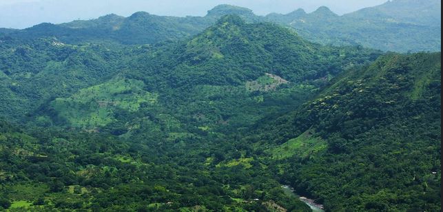
The South Ahuachapán landscape
- The South-Ahuachapán area, located in the department of Ahuachapán, includes the municipalities of San Francisco Menendez, Jujutla, Guaymango and San Pedro Puxtla (Figure 9), covering an area of 591.73 Km2, with a population of 98,016 people from which 51% are women, and with the majority of the population (77%) residing in rural areas[10].
- The MARN estimates the South-Ahuachapán as an area of high vulnerability to climate change. Considering its environmental and social characteristics at the landscape level, this part of the country finds itself highly susceptible to the destructive effects of climate variability together with lacking of necessary resources to adequately prepare, respond and recover from natural disasters. This region, contains a significant amount of the population exposed to frequent meteorological drought, while at the same time it is one of El Salvador’s main regions for the production of staple food items (basic grains), as well as other cash crops (sugarcane, coffee).
- According to the climate change scenarios produced by the MARN, climate variability and change in the region will become more and more evident. This will be reflected through significant increases in average temperatures, erratic rainfall patterns, and increased frequency and intensity of extreme weather events.
- Tree cover accounts for 68% of its total territorial area, distributed as 33% Forest, 29% Shaded coffee and 6% shrubs. Agricultural land accounts for 26% of total area, and it is used for the production of staple grains (maize and beans). The Landscape features strategic natural assets for the country, such as El Imposible National Park, the Apaneca-Ilamatepec Biosphere Reserve, and the RAMSAR site Barra de Santiago comprising an extraordinary biological diversity of ecosystems, species and genes, and their conservation deserve special attention. The primary ecological zones are the humid subtropical forest to the south, very moist subtropical forest, and humid subtropical forest.
- The area has a complex hydrographic network. Of the 11 hydrographic basins that drain the territory, four of the most important: the rivers La Paz, Banderas, Lempa and Grande in Sonsonate are part of this area. There are 32 rivers in the Barra de Santiago Basin - and the Sub-basins of Cara Sucia and Culiapa. Among the main rivers of the Cara Sucia Sub-basin are El Sacramento, Huiscoyol, El Corozo, Cara Sucia, Mistepe, the Izcanal, Maishtapula, and the Aguachapio rivers. Between the main rivers of the Cuilapa Sub-basin are the Guayapa, Cuilapa, El Naranjo, El Rosario, Cubis, San Antonio, Tihuicha and El Negro rivers. However, a Hydro Analysis of this area carried out in 2007, showed that domestic demand represented 7.41% of total demand, against an irrigation demand of 92.59%, with signs of over-exploitation of the resource in the lower parts of the Cara Sucia Sub-watershed.
- Since 1974, the Paz River has abandoned old drainages of the El Aguacate, La Danta and Río Seco channels, causing a process of desiccation and transformation of the wetlands and marshes, with an alteration of the salinity gradients, the reduction of the freshwater flows and the closure of the mangrove swamps of Garita Palmera. This leads to a high susceptibility to flooding in the southern part of the Department. The situation will be further aggravated by the climate change impacts projected to take place in what is already degraded land. Ineffective agricultural and livestock practices have led to high levels of contamination by agrochemicals, which, together with erosion, lead to a deterioration of mangroves with sedimentation and silting of channels, with loss of mangrove hydrodynamic regulation. This situation, threatens and affects artisanal and industrial fishing and local livelihoods. The lack of opportunities leads to migration and weakening of the social fabric in an already vulnerable part of the country.
- In this region, the mangroves in the lower basin of the river belong to the mangrove ecoregion of the Pacific dry coast (Olson et al., 2001), which extend in patches along the coastal zone of Guatemala and El Salvador. The mangroves and marshes dominate the coasts of estuaries in the coastal plain. The coastal wetlands of Garita Palmera and El Botoncillo are possibly the least known and certainly the most degraded on the coast of El Salvador (MARN - AECI, 2003), and the population that inhabits these ecosystems have livelihoods intimately related to their services. The current conditions of the mangroves in the lower basin of the river are a consequence of the high rate of deforestation and the change in land use throughout the basin, as well as alterations in its hydrological regime, such as decrease of annual flow, flow seasonal shifts, and significant decrease in water budget of River Paz, causing a reduction in the productivity of ecosystems and in their capacity to provide services and benefits to local communities (further contributing to flooding, increased runoff and soil loss).
- This region is important also for aquifer recharge, specifically for the recharge of the aquifer ESA-01, localized in alluvial materials in south Ahuachapán, in the municipalities of San Francisco Menendez, Jujutla and Acajutla.
- During the last eight years, this landscape has suffered the adverse impacts of extreme hydro-meteorological events, in some years it experienced Tropical Depressions and Hurricanes, and in other years it suffered meteorological drought with significant damages to infrastructure, agriculture and crops, functioning of ecosystems, and livelihoods. The loss of coverage and inadequate agricultural practices on slopes, have caused a decrease in water regulation capacities with increased runoff, which in turn led to a severe increase in soil erosion rates in the high and middle parts of the basins, an increased risk of landslides and floods; and a decrease in infiltration capacities and aquifer recharge with a decrease in the water supply for different uses. All this has been reflected in large damages to infrastructure and crop loss.
- The pressure exerted on the forest remnants of the highlands, riparian forests, secondary forests, agroforestry systems and mangroves has also increased the region’s vulnerability to climate change. The reduction of habitat, the loss of ecological connectivity and of critical ecosystem services (i.e. water provision, climate regulation) have caused a chain of processes and negative impacts that increase the vulnerability of this area in the face of more frequent events of heavy rainfall, and prolonged periods of drought. Thus, the loss of natural vegetation cover and the poor land use practices in agriculture, are leading to a continuous decrease in surface and ground water availability, excessive runoff, and a decrease in other water regulation ecosystem services, leading to a significant increase in soil erosion rates. A recent assessment of damages to the agricultural sector in Ahuachapán, pointed out that, due to an extended drought period, the average numbers observed for the harvest of corn and beans (June/July 2015) had a reduction of 94%.
- Degrading of natural ecosystems, with wide spread effects at the landscape level (including depletion of riparian forests and grasslands) threatens the provision of a wide range of ecosystem services to local communities in the South Ahuachapán. Long and short-term effects of degradation of these ecosystems include:
- increased soil erosion as a result of reduced vegetation cover;
- reduced infiltration of water in degraded watersheds and catchment areas, thereby resulting in reduced recharge of groundwater and an increased incidence of flooding;
- Interventions in the are thus need to focus on helping the landscape to adapt and build resilience to the impacts of climate change, through the protection of the ecosystems and the rehabilitation and conservation of the mosaic of interdependent land uses thus enhancing the landscape’s capacity to manage extreme hydro-meteorological events as well as increased projected temperatures and erratic rainfall patterns. The goods and services generated by healthy or under restoration landscapes, have the potential to mitigate these threats by providing multiple benefits to local communities in the region of South-Ahuachapán, such as the provision of natural resources (food and water) and regulatory functions, including flood mitigation, water filtration and waste decomposition.
Landscape approach to build resilience and adapt to climate change
- In 2012, El Salvador developed the National Environmental Policy to help regulate, manage, protect the country’s natural resources, and reverse environmental degradation, while reducing the country’s vulnerability to climate change, which feeds directly into the country’s plans on long-term economic growth and social progress outcomes. A key instrument of the National Environmental Policy is the National Program for the Restoration of Ecosystems and Landscapes (PREP), which is organized in three strategic areas: 1) Restoration, reforestation and inclusive conservation of critical ecosystems such as gallery forests, water recharge areas, slopes, mangroves and other forest ecosystems; 2) The restoration of degraded soils, through the forestation of agricultural systems, the adoption of resilient agroforestry systems and the development of sustainable and climate-resilient and biodiversity-friendly agriculture; 3) Synergistic development of physical infrastructure and natural infrastructure. Forest landscape restoration is a key part of the country’s Nationally Determined Contribution, and the main strategy to contribute to climate change adaptation, by increasing productivity of landscapes, enhancing the resilience of forest ecosystems, landscapes, agroecosystems, watersheds, and forest‐dependent communities.
- The PREP comprises immediate and strategic activities, such as the conservation of forest remnants; the restoration of forest ecosystems and agroecosystems, recovering tree coverage in critical sites, working to rehabilitate the landscape; and the maintenance and increase of tree cover in critical areas, particularly in high altitude agroecosystems, and at the watershed level (to control water supply and flow, reducing runoff, landslides and floods). The application of techniques to reduce the speed of the water flow and to increase the capacity of the water retention in the upper sections of the basins and the high zones of the mountain ranges and the protection of the plant cover, have the potential to reduce erosion and the transport of sediment as well as floods. Consequently, it enables to reduce risks associated to extreme hydro-meteorological events. Furthermore, it is expected that the reforestation of the agricultural areas will improve the soil with an increase in organic matter and moisture retention, and therefore, increasing the resistance during water shortage and drought.
Identification of priority sites for EBA through restoration in South Ahuachapán
- Information from the PREP was used o update National Land Use Map, allowing for the identification of key the restoration sites of the country based on the following six criteria: soil conservation and food production; biodiversity and wildlife conservation; protection of ground water and adaptation to drought; adaptation to extreme events and protection against floods and storms; firewood supply and climate regulation.
- A particular focus was provided to key agroecosystems sites (these account for 60% of the national territory) with the potential land use/cover transitions[11] for restoration also being identified taking into account the different current uses of the soil to allow the recovery of prized ecosystems, through the restoration of their relevant environmental goods and services for adaptation. The potential areas for each transition type comprise a total of 1,001,405 hectares comprising eleven proposed transitions pointing to the high potential for restoration areas in South Ahuachapán.
- The analysis by MARN has allowed the project to identify the municipality of San Francisco Menendez located in the South Landscape of Ahuachapán, as the target intervention area for restoration investments. The municipality has a territory of 226.13 km2 and a total population of 42,062 of which 30,211 reside in rural areas. The identification of the Municipality of San Francisco Menendez as the area of intervention, was based on an exhaustive analysis of available time series of satellite remote sensing data, together with data and information collected by MARN in-situ.[12]
- To further characterize the imbalances observed in the region, coming as consequence of intense rainfall and longer dry periods, the prioritization exercise used data from the Monthly Climate and Climatic Water Balance for Global Terrestrial Surfaces Dataset (TerraClimate) to better understand the runoff patterns in San Francisco Menendez.[13] The analysis revealed an upward trend in surface runoff in San Francisco Menendez, starting in 2006 and progressing steadily, affecting negatively agricultural activities and exacerbating the already damaging effects of extended periods of drought, scarce and localized rainfall patterns in the intervention area. The data and analysis revealed that the lower Rio Paz presents a remarkably consistent pattern of low precipitation and high temperatures over time. Such characteristics have been followed by an increase in the number of extreme whether events (such as heavy rainfall and droughts), leading to below average soil moisture, increased surface runoff, and soil loss. This has been pointed out by an increasing number of recent reports by MARN and international agencies such as USAID, FAO, GIZ, which have identified the Municipality of San Francisco Menendez (entirely located in the Central America Dry Corridor) as extremely susceptible to the Effects of CC. The impacts pointed out by MARN and international organizations working in the area, have been immediately felt in the form of changes in water flow patterns (in the Lower Rio Paz), higher than normal temperatures, erratic rainfall, and low fresh water input into the ocean. This has created an imbalance that will only be exacerbated by CC, affecting agriculture, the natural environment, as well as local livelihoods in the project intervention areas.
- In San Francisco Menendez, the land under exploitation is dominated by cultivation of crops (46%), followed by seasonal grasslands (30%) and permanent grasslands (15%). The local development plan for the municipality has identified 4,569 Ha of critical ecosystems for restoration by 2030 of which 1,569Ha are agroforestry systems, 2,000 Ha tropical forests and 1,000 Ha being mangrove systems. According to the 2007 Census in the agriculture and livestock sector, the land under exploitation is mainly owned by producers (75%) while 18% of land is leased (Figure 13). There are 80 cooperatives of small producers present in San Francisco Menendez, from those 16 are women led cooperatives.
- San Francisco Menendez municipality is part of the broader South Ahuachapán landscape that includes the municipalities of Jujutla, Guayamango and San Pedro Puxtla. These municipalities are administratively grouped together through the Association of Municipalities of Microregión Sur with the objective of establishing synergies for their development and for environmental management through concerted actions. Actions along these municipalities is also strategic as these also share access to the same aquifers (Figure 12) thus linking them, at a landscape, administrative and hydrological level. Population for this larger region is 98,016 (49,899 women) of which 75,515 people reside in rural areas.
[1] D. L. Hartmann, a. M. G. K. Tank, and M. Rusticucci, “IPCC Fifth Assessment Report, Climatie Change 2013: The Physical Science Basis,” Ipcc AR5, no. January 2014 (2013): 31–39, https://doi.org/10.1017/CBO9781107415324.
[2] IPCC, “Climate Change, Adaptation, and Vulnerability,” Organization & Environment 24, no. March (2014): 1–44, https://doi.org/http://ipcc-wg2.gov/AR5/images/uploads/IPCC_WG2AR5_SPM_Approved.pdf.
[3] Sönke Kreft and David Eckstein, “Global Climate Risk Index 2014,” Germanwatch, 2013, 28, http://germanwatch.org/en/download/8551.pdf.
[4] (Cai et al., 2015; Harger, 1995; Neelin et al., 1998; Takahashi et al., 2011; Torrence and Webster, 1999; Wolter and Timlin, 2011)
[5] Ministry of Economy; General Directorate of Statistics and Census –DIGESTyC; El Salvador: 2014; Estimates and Trends of Municipal Population 2005-2025
[6] STPP and MINEC-DIGESTYC (2015). Multidimensional Measurement of poverty. El Salvador. San Salvador: Technical and Planning Secretariat of the Presidency and the Ministry of Economy, through the General Directorate of Statistics and Census.
Compound Poverty: Takes into account the essential areas for human development and well-being. A total of twenty indicators around five essential well-being dimensions: a) education; b) housing conditions; c) work and social security; d) health, basic services and food security; and e) quality of the habitat.
[7] STPP & MINEC-DIGESTYC, “Medición Multidimensional de La Pobreza. El Salvador.,” San Salvador: Secretaría Técnica y de Planificación de La Presidencia y Ministerio de Economía, a Través de La Dirección General de Estadística y Censos., 2015.
[8] Minerva Campos et al., “Estrategias de Adaptación Al Cambio Climático En Dos Comunidades Rurales de México y El Salvador,” Adaptation Strategies to Climate Change in Two Rural Communities in Mexico and El Salvador, no. 61 (2013): 329–49, http://www.boletinage.com/61/16-CAMPOS.pdf.
[9] For example, accumulated rainfall in the southeast area of the country was less than 10 mm, representing a 95% deficit from average rainfall
[10] Almanaque 262. State of human development in the municipalities of El Salvador, 2009.
[11] Defined as the non-linear land use change process associated with societal and biophysical system changes.
[12] The analysis was conducted using Google Earth Engine, allowing the production of wall-to-wall spatially explicit information at multiple spatial scales. The analysis included Climate models generated by both long-term climate predictions and historical interpolations of surface variables, including historical reanalysis data from NCEP/NCAR, gridded meteorological datasets such as the NLDAS-2, and GridMET, and climate model outputs like the University of Idaho MACAv2-METDATA and the NASA Earth Exchange’s Downscaled Climate Projections. The prioritization also included the analysis of spatially-explicit land surface variables over time, such as: Evapotranspiration/Latent Heat Flux product (8-day composite product produced at 500 meter pixel resolution), providing information on the hydrologic cycle, which has direct and significant influence on agriculture cycles in the region, as well as the amount of solar radiation, atmospheric vapor pressure, temperature, wind, and soil moisture available. The prioritization also included analysis of salinity anomalies using the Hybrid Coordinate Ocean Model, Water Temperature and Salinity (HYCOM) (Revealing that salinity has not been decreasing as result of local meteorological processes over the past several years). The analysis also included Long-Term drough Severity estimations using the Palmer Drought Severity Index (PDSI), which has been effective in effective in determining long-term drought in the intervention area. The PDSI data and analysis considers surface air temperature and a physical water balance models, taking into account the observed effects of increasingly warm temperatures, and high evapotranspiration, leading to systemic imbalances affecting local hydrological cycles (refer back to Figure 13).
[13] This dataset and analysis considers runoff as the excess of liquid water supply (precipitation) used by monthly Evapotranspiration and soil moisture recharge and is derived using a one-dimensional soil water balance model and it correlates well to measured streamflow from a number of watersheds globally.


- UNDPMontserrat XilotlRegional Technical Adviser, Climate Change Adaptation