
Photo:
Lao PDR is vulnerable to severe flooding, often associated with tropical storms and typhoons, as well as to drought.
Increases in temperature and the length of the dry season are expected to increase the severity of droughts and increase water stress, particularly in cultivated areas. The frequency and intensity of floods are also likely to increase with climate change.
Led by the Government of Lao PDR with support from the UN Development Programme, this 4-year project will increase the resilience of communities in two particularly vulnerable areas – Xe Bang Hieng river basin in Savannakhet Province and the city of Luang Prabang – through:
- Strengthened national and provincial capacities for Integrated Catchment Management and integrated urban Ecosystem-based Adaptation for climate risk reduction;
- Ecosystem-based Adaptation (EbA) interventions with supporting protective infrastructure and enhanced livelihood options;
- Community engagement and awareness-raising around climate change and adaptation opportunities, as well as knowledge-sharing within and outside Lao PDR; and
- The introduction of community-based water resource and ecological monitoring systems in the Xe Bang Hieng river basin.
- Community
- District
- National
- Country Office
- Local Governments
- National Governments
- Non-Governmental Organizations
- Private Sector Partners
- United Nations Development Programme (UNDP)
The proposed project will directly benefit 492,462 people (including 247,991 women) by increasing the climate resilience of communities in nine districts in Savannakhet Province, as well as the city of Luang Prabang, through facilitating the adoption of ICM at the provincial and national level and urban EbA at the local level. Government ministries at central and provincial levels will also benefit from capacity-building; development of relevant plans; technical support; coordination; and mobilisation of human and financial resources.
- Department of Water Resources, Ministry of Natural Resources and Environment, Lao PDR
- United Nations Development Programme (UNDP)
- Global Environment Facility (GEF)
Expected outcomes
Component 1: Developing national and provincial capacities for Integrated Catchment Management and integrated urban Ecosystem-based Adaptation for climate risk reduction
Outcome 1.1: Enhanced capacity for climate risk modelling and integrated planning in the Xe Bang Hieng river basin and Luang Prabang urban area
Output 1.1.1: Central and Provincial training program implemented to enable climate risk-informed water management practices in target urban and rural areas
Output 1.1.2: Current and future zones of the Xe Bang Hieng River catchment at risk of climate change-induced flooding and drought mapped, based on hydrological models produced and protective infrastructure optioneering conducted
Output 1.1.3. Economic valuation of urban ecosystem services in Luang Prabang and protective options conducted.
Outcome 1.2: Alignment of policy frameworks and plans for land and risk management to support long-term climate resilience
Output 1.2.1: Fine-scale climate-resilient development and land-use plans drafted and validated for Luang Prabang and in the headwater and lowland areas of the Xe Bang Hieng and Xe Champone rivers.
Output 1.2.2: Current Xe Bang Hieng river basin hydrological monitoring network — including village weather stations — assessed and updated to improve efficiency.
Output 1.2.3: Early-warning systems and emergency procedures of vulnerable Xe Bang Hieng catchment communities (identified under Output 1.1.2) reviewed and revised
Component 2: Ecosystem-based Adaptation (EbA) interventions, with supporting protective infrastructure, and livelihood enhancement
Outcome 2.1: Ecosystems restored and protected to improve climate resilience in headwater areas through conservation zone management
Output 2.1.1: Xe Bang Hieng headwater conservation zones restored to ensure ecological integrity is improved for delivery of ecosystem services
Output 2.1.2: Headwater conservation zone management supported to improve resilience to climate change
Outcome 2.2: EbA interventions supported/complemented with innovative tools, technologies and protective infrastructure
Output 2.2.1: Protective infrastructure constructed to reduce flood (cascading weirs and drainage channels) and drought (reservoir networks and rainwater harvesting) risk
Output 2.2.2: Implementation and distribution of communication and knowledge management tools and technologies (e.g. mobile phone apps, community radio) to increase climate resilience of agricultural communities to floods and droughts
Outcome 2.3: Climate-resilient and alternative livelihoods in headwater and lowland communities, supported through Community Conservation Agreements
Output 2.3.1: Market analysis conducted, including; i) analysing supply chains for climate-resilient crops, livestock, and farming inputs; ii) assessing economic impacts and market barriers; and iii) drafting mitigating strategies to address these barriers.
Output 2.3.2: Community Conservation Agreements process undertaken to encourage climate-resilient agriculture, fisheries, and forestry/forest-driven livelihoods and practices
Output 2.3.3: Diversified activities and opportunities introduced through Community Conservation Agreements (developed under Output 2.3.2) in agriculture (livestock and crops, including vegetable farming) as well as fisheries, non-timber forest products (NTFP), and other off-farm livelihoods.
Component 3: Knowledge management and monitoring, evaluation and learning
Outcome 3.1: Increased awareness of climate change impacts and adaptation opportunities in target rural and urban communities
Output 3.1.1: Training and awareness raising provided to Xe Bang Hieng and Xe Champone headwater and lowland communities on: i) climate change impacts on agricultural production and socio-economic conditions; and ii) community-based adaptation opportunities and strategies (e.g. water resources management, agroforestry, conservation agriculture, alternatives to swiddening ) and their benefits
Output 3.1.2: Project lessons shared within Lao PDR and via South-South exchanges on strengthening climate resilience with regards to: i) catchment management; ii) flash flood management; and iii) EbA.
Output 3.1.2: Awareness-raising campaign conducted in Luang Prabang for communities and the private sector on urban EbA and flood management.
Outcome 3.2: Community-based water resource and ecological monitoring systems in place
Output 3.2.1: Community-based monitoring systems developed and implemented to measure changes in key ecological determinants of ecosystem health and resilience in the Xe Bang Hieng river basin
- Image
- Image
- Image
- Image
- Image
- Image
- Image
General context
The Lao People’s Democratic Republic is a landlocked Least Developed Country in Southeast Asia. It has a population of ~7.1 million people and lies in the lower basin of the Mekong River, which forms most of the country’s western border with Thailand.
Its GDP has grown at more than 6% per year for most of the last two decades and reached ~US$ 18 billion in 2018 (~US$ 2,500 per capita). Much of this economic growth has been dependent on natural resources, which has placed increasing pressure on the environment. Agriculture accounts for ~30% of the country’s GDP and supports the livelihoods of 70–80% of the population.
Impacts of climate change
The country is vulnerable to severe flooding, often associated with tropical storms and typhoons, as well as to drought.
In 2018, for example, floods across the country resulted in ~US$ 370 million (~2% of GDP) in loss and damage, with agriculture and transport the two most affected sectors. Floods in 2019 — the worst in 4 decades — affected 45 districts and ~768,000 people country-wide floods, resulting in US$162 million in costs.
An increase in the frequency of these climate hazards, including floods and droughts, has been observed since the 1960s, as well as an increase in the average area affected by a single flood.
Following the floods, the Government identified several priorities for responding to flood risk in the country, including:
- Improving flood and climate monitoring and early warning systems;
- Public awareness raising to respond to disasters and climate change;
- Building resilience at community level; iv) improved risk and vulnerability mapping; and
- Strengthening the capacity of government at the provincial, district and community level for better climate change-induced disaster response.
In addition, average increases in temperature of up to 0.05°C per year were observed in the period between 1970 and 2010. These trends are expected to continue, with long-term climate modelling projecting: i) an increase in temperature between 1.4°C and 4.3°C by 2100; ii) an increase in the number of days classified as “Hot”; iii) an increase of 10–30% in mean annual rainfall, particularly in the southern and eastern parts of the country and concentrated in the wet season (June to September); iv) an increase in the number of days with more than 50 mm of rain; v) a 30–60% increase in the amount of rain falling on very wet days; and vi) changing rainfall seasonality resulting in a longer dry season.
The increases in temperature and the length of the dry season are expected to increase the severity of droughts and increase water stress, particularly in cultivated areas. The frequency and intensity of floods are also likely to increase as a result of the projected increase in extreme rainfall events — associated with changes iv) and v) described above.
About the project under development
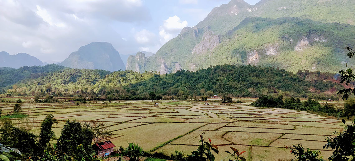
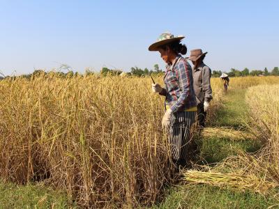
The proposed project focuses on strengthening integrated catchment management (ICM) and integrated urban flood management within the Xe Bang Hieng river basin in Savannakhet Province – a major rice-producing area and particularly important for the country’s food security, as well as one of the areas in the country which is most vulnerable to droughts and experienced severe flooding in 2017, 2018 and 2019 – and the city of Luang Prabang – one of the cities in Lao PDR which is most vulnerable to flooding, as well as being an important cultural heritage site – for increased climate resilience of rural and urban communities.
The approach will ensure that water resources and flood risks are managed in an integrated manner, considering the spatial interlinkages and dependencies between land use, ecosystem health and underlying causes of vulnerability to climate change.
The protection and restoration of important ecosystems will be undertaken to improve the provision of ecosystem goods and services and reduce the risk of droughts, floods and their impacts on local communities, thereby increasing their resilience to the impacts of climate change.
Improved hydrological and climate risk modelling and information systems will inform flood management as well as adaptation planning in the Xe Bang Hieng river basin and Luang Prabang. This information will be made accessible to national and provincial decision-makers as well as local stakeholders who will be trained to use it.
Using the ICM and integrated urban flood management approaches and based on integrated adaptation planning, on-the-ground interventions to improve water resource management and reduce vulnerability to floods and droughts will be undertaken, including ecosystem-based adaptation (EbA).
These interventions will be complemented by capacity development and awareness raising as well as support for rural communities to adopt climate-resilient livelihood strategies and climate-smart agricultural practices.
Addressing gender equality
The proposed project will promote gender equality, women’s rights and the empowerment of women in several ways.
First, the proposed activities have been designed taking into account that in Lao PDR: i) women’s household roles should be considered in any interventions concerning natural resource management, land-use planning and decision-making; ii) conservation incentives differ for men and women; iii) gendered division of labour needs to be understood prior to the introduction of any livelihood interventions; and iv) women need to have access to, and control over, ecosystem goods and services.
Second, an understanding of gender mainstreaming in relevant sectors and associated ministries will be developed, and gaps in gender equality will be identified and addressed in all aspects of project design.
Third, women (and other vulnerable groups) will be actively involved in identifying environmentally sustainable activities and interventions that will support them in safeguarding natural resources and promoting their economic development, with specific strategies being developed to target and include female-headed households. To ensure that the project activities are both gender-responsive and designed in a gender-sensitive manner, a gender action plan will be developed during the project preparation phase.


Component 1: Developing national and provincial capacities for Integrated Catchment Management and integrated urban Ecosystem-based Adaptation for climate risk reduction
Outcome 1.1: Enhanced capacity for climate risk modelling and integrated planning in the Xe Bang Hieng river basin and Luang Prabang urban area
Outcome 1.2: Alignment of policy frameworks and plans for land and risk management to support long-term climate resilience
Component 2: Ecosystem-based Adaptation (EbA) interventions, with supporting protective infrastructure, and livelihood enhancement
Outcome 2.1: Ecosystems restored and protected to improve climate resilience in headwater areas through conservation zone management
Outcome 2.2: EbA interventions supported/complemented with innovative tools, technologies and protective infrastructure
Outcome 2.3: Climate-resilient and alternative livelihoods in headwater and lowland communities, supported through Community Conservation Agreements
Component 3: Knowledge management and monitoring, evaluation and learning
Outcome 3.1: Increased awareness of climate change impacts and adaptation opportunities in target rural and urban communities
Outcome 3.2: Community-based water resource and ecological monitoring systems in place
The overall monitoring and evaluation of the proposed project will be overseen by the Department of Planning under the Ministry of Planning and Investments, which carries out M&E for all planning processes in the country.

- Ms. Keti ChachibaiaRegional Technical Advisor for Climate Change Adaptation, UNDP