
Photo:
The Green Climate Fund-financed project 'Coastal Resilience to Climate Change in Cuba through Ecosystem Based Adaptation (‘MI COSTA')’ responds to the coastal adaptation needs of Cuba due to climate-change related slow onset events such as sea level rise and flooding arising from extreme weather events. Impacts from these climate drivers are a matter of national security for the people of this small-island state and pose an existential threat to coastal settlements and communities. Projections show that if no intervention is made by 2100, up to 21 coastal communities will disappear with a further 98 being severely affected by climate related threats (flooding, coastal erosion and saline intrusion).
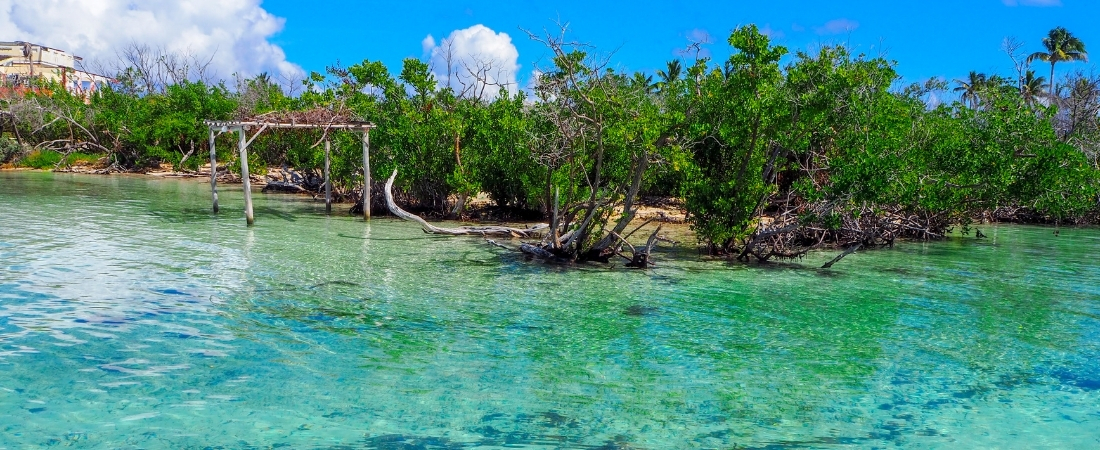
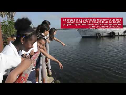
Cuba’s southern coast has been selected due its high vulnerability to climate change particularly in the form of coastal flooding and saline intrusion. 1,300 km of coastline, 24 communities, and 1.3 million people will directly benefit from the project. In protecting life on land and below the water, 11,427 ha of mangroves, 3,088 ha of swamp forest and 928 ha of grass swamp will be restored, which in turn will improve the health of 9,287 ha of seagrass beds and 134 km or coral reef crests.
The project will enhance adaptive capacity by holistically rehabilitating coastal land-seascapes, their interlinked ecosystems and hydrology. This will be achieved by rehabilitating ecosystem functions and connections within mangroves and swamp forests and reducing anthropic pressures to marine coastal ecosystems, thus enhancing the services supplied by integrated coastal ecosystems (particularly protection from saline flooding and erosion, and channelling freshwater to coastal areas and aquifers). It will also strengthen the adaptive capabilities of coastal governments and communities´ by building their capacity to utilize and understand the benefits of ecosystem-based adaptation, enhancing information flow between stakeholders and strengthening the regulatory framework for territorial management in coastal areas.
- Community
- National
- Country Office
- National Governments
- United Nations Development Programme (UNDP)
- Government of Cuba
- Green Climate Fund
- United Nations Development Programme (UNDP)
Expected outcomes
Output 1: Rehabilitated coastal ecosystems for enhanced coping capacity to manage climate impacts.
Output 2: Increased technical and institutional capacity to climate change adaptation in coastal communities, governments and economic sectors.
Output 3: Project management.
- Image
- Image
- Image
Climate change impacts and threats
The Cuban archipelago’s location in the Caribbean, places it in the path of frequent tropical storms, and the long, narrow configuration of the country is such that no part of the country is very far from the sea (over 57% of the population lives in coastal municipalities).*
Coastal municipalities and their respective settlements are also extremely vulnerable to climate change (CC) due to increased storms and rising sea levels, resulting in increased coastal flooding caused by extreme meteorological phenomena such as tropical cyclones, extratropical lows, and strong winds from surges. From 2001 to 2017, the country has been affected by 12 hurricanes 10 which have been intense (category 4 or 5), the highest rate in a single decade since 1791. In the past 10 years the percentage of intense hurricanes affecting the country has risen from a historical average of 26% to 78% with accompanying acute losses. These intense hurricanes impacting Cuba since 2001 coincide with very high sea surface temperatures (SSTs) in the tropical Atlantic recorded since 1998.
The coasts of Cuba in the past three decades have also seen an increase in the occurrence of moderate and strong floods as a result of tropical cyclones and of extratropical systems; with extratropical cyclones being associated with the highest rates of flooding in the country. Furthermore, warm Pacific El Niño events lead to an increase in extra-tropical storms which increase the risks of flooding along the coastline.
CC induced Sea Level Rise (SLR) will aggravate coastal flooding affecting in particular low-lying coastal areas. It is expected that through SLR, mean sea level will increase by 0.29 m by the year 2050 and between 0.22m and 0.95m by the year 2100 impacting 119 coastal settlements in Cuba. Combining increased storm surge and projected SLR, flooding of up to 19,935 km² (CC + Category 5 hurricane) and 2,445 km² (CC + normal conditions) can be expected by the year 2050.
These estimates could be higher when compounded by the impact of surface water warming on the speed of storms, and new research that links it to increased wave heights in the Caribbean. Under this scenario, storms could be more frequent and move at a slower pace thus increasing the impact on island states such as Cuba.
CMIP5 projections indicate that by 2050, mean annual temperature in Cuba will rise by a median estimate of 1.6°C; total annual extremely hot days (temperature >35°C) will rise by a median estimate of 20 days (RCP 4.5) and 20.8 days (RCP 8.5). Associated increases in potential evapotranspiration will further lead to more frequent severe droughts, as already observable in eastern Cuba.
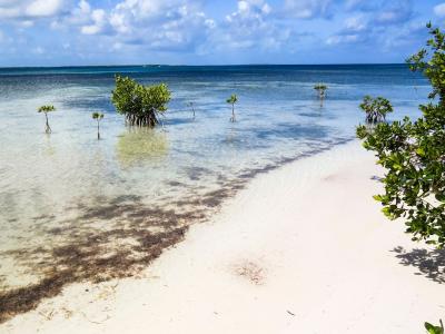
Cuban coastal seascapes and landscapes are a succession of ecosystems that have coevolved under current climatic conditions, including current distributions of extreme events. The progression of coral reefs, seagrass meadows, beaches, coastal mangroves and forest or grassland swamps represents an equilibrium that confers resilience to each ecosystem separately but also to the coast as a whole. The current resilience of Cuban coastal ecosystems to extreme events and SLR, is being undermined by both climate change effects (increased extreme events) and other anthropogenic pressures, tempering their capacity to provide their protective services. Mangroves have further suffered high levels of degradation affecting their ability to colonize new areas, reduce wave impacts, accrete sediments and stabilize shorelines. Additionally, coral reefs have shown signs of bleaching and degradation that have been attributed to mangrove and sea grass degradation (including the alteration of hydrological natural flows, presence of invasive species, water contamination, and habitat destruction), climate-related increases in surface water temperature and to increased impacts of hurricanes.
SLR will further increase current vulnerabilities and stresses on ecosystems due to increases in water depth and wave energy which will increase coastal erosion, coastal flooding and saline intrusion risks.
Coastal erosion
Current coastal erosion rates are attributed to a combination of natural dynamics (waves, currents, extreme events, hurricanes, etc.) and human interventions (natural resources extraction, wetlands filling, coastal infrastructure construction excluding natural dynamics, habitat loss, water diversion, etc). An increase in the magnitude of extreme events and increasing SLR will accelerate erosion related to natural processes, which currently averages 1.2 m/year (calculated between 1956-2002). This erosion rate poses a danger to communities, infrastructure and natural habitats that are not tolerant to saline intrusion and provide services to landward communities.
Flooding
Coastal flooding as a combination of high rainfall, high sea levels and storm surges has been identified as one of the primary climate change related threats to Cuba. Trends in the frequency of coastal floods during the period 1901-2011 have been observed in Cuba with the past three decades seeing an increase in the occurrence of moderate and strong floods, regardless of the meteorological events that generate them. Specific impacts and the extent of resulting damages depend on local bathymetry and topography, seabed roughness and coastal vegetation coverage and conditions, with the coastal regions of La Coloma- Surgidero de Batabano and Jucaro-Manzanillo being particularly vulnerable.
Hurricanes have also extensively damaged infrastructure. Hurricane Matthew, which crossed the eastern end of Cuba in October 2016, caused USD 97.2 million of damages (approximately 2.66% of GDP), making it the third most devastating hurricane to hit the island in the last decade, only behind Ike (2008) and Sandy (2012), with equivalent costs of USD 293 million (12.05% of GDP) and USD 278 million (9.53 % of GDP) respectively.
Saline intrusion
Saline intrusion into aquifers is the most common and extensive cause of freshwater degradation in Cuba’s coastal zones. Most of these aquifers, located near and beneath the northern and southern coasts, are open to the sea, making them very susceptible and exposed to saline intrusion as a result of SLR, and potentially leading to water that is too saline for human consumption and increasing the salinization of agricultural fields. It is estimated that approximately 544,300 ha in the area of proposed interventions are already affected by saline intrusion.
Drought
Drought has been identified among the most important climate risks for all Caribbean islands, including Cuba. There has been an increase in drought events in the period 1961-1990 when compared to 1931-1960. Severe droughts have been increasing in eastern Cuba and are projected to increase in the future. Future projections indicate a general reduction in rainfall by 2070 (particularly along the Eastern Coastline), along with an average reduction in relative humidity between 2% and 6% between 2030 and 2070, respectively. Reduced rainfall occurring mostly during the summer rainy season, with relatively smaller increases in winter and dry season rainfall. This situation adds an increase pressure on the aquifers, which cannot be filled by just one tropical storm, or during the rainy season.
Vulnerability Southern Coast of Cuba, project target site
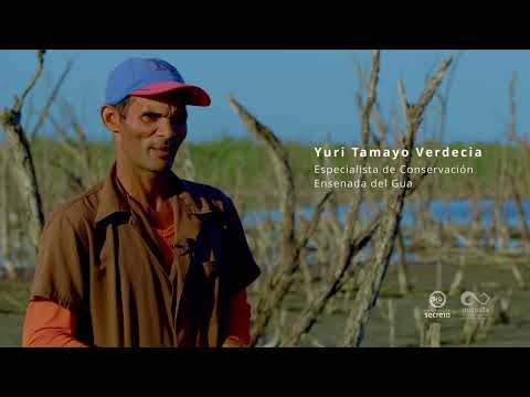
Cuba’s coastal ecosystems have been extensively studied through extensive research led by The Ministry of Science, Technology and Environment (CITMA), the Environmental Agency (AMA) and the Scientific Institute for the Sea (ICIMAR). ICIMAR’s research on coastal dynamics and vulnerability is the foundation for Cuba’s National Environmental Strategy (NES) and its State Plan for Facing Climate Change (“Tarea Vida”, 2017) which outlined coastal areas in eminent danger as national priority.
A research-based CC vulnerability ranking (high, medium, and low) was designed considering a combination of factors: geological, geomorphological and ecosystem degradation highlighting that vulnerability to sea-level rise and associated events is higher in the country’s low-lying coasts. Settlements in these areas are more vulnerable to SLR and more likely to be affected by extreme weather events (hurricanes, tropical storms) because of their low elevation, largely flat topography, extensive coastal plains and the highly permeable karstic geology that underlies it; hence more exposed and susceptible to flooding and saline intrusion. These areas have been targeted as the project’s area of intervention, prioritized within “Tarea Vida,” with attention being paid to two coastal "stretches" totaling approximately 1,300 km of coastline and 24 municipalities covering 27,320 km2.
Main localities for direct intervention of EBA include settlements with high vulnerability to coastal flooding, facing saline intrusion and with a contribution to economic life including those with major fishing ports for shrimp and lobster. Settlements with coastal wetlands that represent a protective barrier for important agricultural production areas to reduce the effects of saline intrusion on the underground aquifers and agricultural soils where also considered.
Southern Coastal Ecosystems
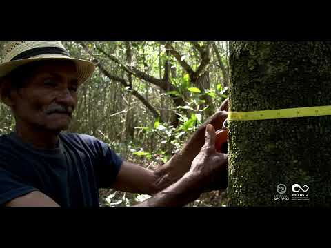
Coastal ecosystems in the targeted coastal stretches are characterized mainly by low, swampy and mangrove-lined shores surrounded by an extensive, shallow submarine platform, bordered by numerous keys and coral reefs. In these areas mangroves and marshes could potentially act as protective barriers against storm surges, winds and waves and therefore reduce coastal erosion, flooding and salt intrusion associated risks. These ecosystems can keep pace with rising seas depending on sediment budgets, frequency of disturbances, colonization space, and ecosystem health.
There are numerous reported functional relationships between coastal and marine ecosystems, including sediment binding and nutrient absorption, which combined with water retention, create equilibrium dynamics and coastal stability. Freshwater infiltration is favored by swamp forests reducing saline intrusion risk and organic matter exchange facilitates favorable conditions for healthy seagrass beds and coral reefs. Restoration of these fluxes and connections is required to increase these ecosystems resilience to a changing climate and strengthening their protective role.
Coastal ecosystems and their complex interconnections provide a variety of services to communities, including coastal protection and disaster risk reduction. These services can be enhanced with healthy ecosystems, functional connections and when adequately integrated into land/marine planning policies.
Project focus
The project will focus on actions along Cuba’s Southern Coast that has been selected due its high vulnerability to climate change (open aquifers, low lying coastal plain, degraded ecosystems and concentration of settlements), particularly to storms, drought and sea level rise, which result in coastal flooding and saline intrusion.
Targeted shores cover approximately 89,520 hectares of mangroves (representing 16.81% of the country's mangroves) followed by 60,101 hectares of swamp grasslands and 28,146 hectares of swamp forests. These in turn will contribute to improving 9,287 ha of seagrass and 134 km of coral reefs and their respective protective services.
There is evidence of reef crests degradation which in turn could cause significant wave damage in both mangroves and sea grasses reducing further their ability to offer protection against the effects of CC on the coast of Cuba.
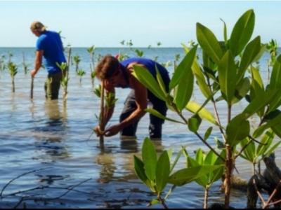
Restoration of degraded red mangrove (Rhizophora mangle) strips along the coastal edges, in stretches 1 and 2, is crucial. During wind, storms and hurricane seasons, the sea has penetrated more than 150 meters inland in these areas, exposing areas dominated by black or white mangroves, which are less tolerant to hyper-saline conditions, potentially becoming more degraded. During stakeholder consultations, communities highlighted the consequent loss of infrastructure and reduced livelihood opportunities (both fisheries and agriculture).
Coastal Stretch 1: La Coloma – Surgidero de Batabanó (271 km – 13,220 km2)
This stretch is made up of 3 provinces (Pinar del Rio, Artemisa and MAyabeque) and 13 municipalities (San Juan y Martinez, San Luis, Pinar del Rio, Consolacion del Sur, Los Palacios, San Cristobal, Candelaria, Artemisa, Alquizar, Guira de Melena, Batabano, Melena del Sur and Guines). The main localities along this stretch are: (1) La Coloma in Pinar del Rio Province; (2) Beach Cajío in Artemisa province; and, (3) Surgidero Batabanó in Mayabeque Province.
The vulnerability assessment concluded that, by 2100, 5 communities in this stretch could disappeared due to SLR. Extreme events, waves’ strength and salinity have also been identified in this area; hence appropriate adaptation measures need to be in place to reduce the impact.
These risks are being exacerbated by the impacts of ecosystem degradation related to changes in land use, pollution past logging, grey infrastructure and inappropriate measures of coastal protection in the past, urbanization, and the reduction of water and sediments flows.
The impact of saline intrusion into the karstic aquifer is particularly troubling along this coastal stretch with important implications at a national level, as the main aquifer, in the southern basin which supplies water to the targeted coastal communities and agriculture, is also an important source of fresh water to the capital, Havana. To address the issue of saline intrusion in this area, the GoC has experimented with grey infrastructure (The Southern Dike), a 51.7 km levee built in 1991 aiming to accumulate runoff fresh water to halt the infiltration of saline water in the interior of the southern aquifer. The USD 51.3 million investment, with maintenance costs of USD 1.5 million every 3 years and a once-off USD 15 million (20 years after it was built), had a positive effect in partially containing the progress of the saline wedge. However, the impact of the dike resulted in the degradation of mangroves in its northern shore reducing the mangroves function to protect the coastline.
Coastal Stretch 2: Jucaro- Manzanillo (1029 km – 14,660 km2)
This stretch is comprised by 4 provinces (Ciego de Avila, Camaguey, Las Tunas and Granma) and 11 muncipalities (Venezuela, Baragua, Florida, Vertientes, Santa Cruz del Sur, Amancio Rodriguez, Colombia, Jobabo, Rio Cauto, Yara and Manzanillo).The main localities to intervene along this stretch include (1) Júcaro in Ciego de Avila Province; (2) Santa Cruz del Sur in Camagüey Province; (3) Manzanillo in Gramma Province (4) Playa Florida.
The communities in this coastal area are located within extensive coastal wetlands dominated by mangroves, swamp grasslands and swamp forest.
Water reservoirs for irrigation have reduced the water flow towards natural ecosystems, it has also been directed towards agricultural lands altering the natural flow indispensable for ecosystems.
Mangroves have been highly impacted by degradation and fragmentation, which has undermined their role in protecting the beach and human populations from extreme hydro-meteorological events, saline intrusion and coastal erosion. Only 6% of mangroves are in good condition, while 91% are in a fair state, and 3% are highly degraded. Wetlands in the prairie marshes have begun to dry due to a combination of climate drivers and land use management with a direct impact in reducing their water retention and infiltration capacity.
Coral crests of the area’s broad insular platform, have been classified as very deteriorated or extremely deteriorated and it is predicted that if no intervention on the sources of degradation from the island, is made, they will disappear by 2100. Reef elimination will increase communities’ flood risk to potentially settlements disappearing.
Saline intrusion is becoming increasingly significant in this area due to a combination of CC-related SLR and the overexploitation of aquifers.
Climate change vulnerability is exacerbated by construction practices (such as people building small shops and walkways) along the shoreline where fully exposed infrastructure can be found within flood zones, between the coast and the coastal marsh. This situation is aggravated by the limited knowledge of local actors and a false sense of security that was perceived during community consultations.
Baseline investment projects
Traditionally, Cuba´s tropical storms response and management strategies have focused on emergency preparation and attendance rather than on planning for disaster risk reduction. The GoC has successfully introduced early warning mechanisms and clear emergency protocols to reduce the impact of storms in the loss of lives. The development of Centres for Risk Reduction Management (CGRR) has also been successful in mobilizing local actors when storms are predicted to hit ensuring that emergency resources are available to address storms’ immediate impacts. While these are important steps in the face of an immediate emergency, they are insufficient to manage multiple ongoing threats (some of slow consequence of climate change).
In 2017, GoC approved its State Plan to Face Climate Change (“Tarea Vida”) in which identified and prioritized the impacts of saline intrusion, flooding and extreme events to the country coastal zones, focusing strategic actions for the protection of vulnerable populations and of key resources including protective ecosystems such as mangroves and coral reefs. The GoC has begun to look into various strategies to mainstream local adaptation initiatives using existing successful national mechanisms for capacity building and knowledge transfer and international cooperation best practices.
Initial investments made by the GoC have identified the country´s climate vulnerability, including drought and SLR vulnerability and hazard risk assessment maps. The development of the “Macro-project on Coastal Hazards and Vulnerability (2050-2100)”, focused on these areas´ adaptation challenges including oceanographic, geophysical, ecological and infrastructure features, together with potential risks such as floods, saline intrusion and ocean acidification. Cross-sectoral information integration was a key tool to identify climate risks and potential resources (existing instruments, institutions, knowledge, etc) to manage it. While this is an important foundation it has yet to be translated into concrete actions often as a result of lack of technical equipment.
International cooperation has financed projects that have further allowed the GoC to innovate on various institutional mechanisms such as the Capacity Building Centres (CBSCs) and Integrated Coastline Management Zones through active capacity building incorporating municipal and sectoral needs. Table 1 summarizes the most relevant baseline projects and highlights key results, lessons learned, and gaps identified. The proposed project aims to address such gaps, and incremental GCF financing is required to efficiently achieve efficient climate resilience in the target coastal sites.
* Footnotes and citations are made available in the project documents.


Output 1: Rehabilitated coastal ecosystems for enhanced coping capacity to manage climate impacts.
1.1 Assess and restore coastal wetland functions in target sites by reestablishing hydrological processes
1.2 Mangrove and swamp forest rehabilitation through natural and assisted regeneration for enhanced coastal protection
1.3 Record and asses coastal and marine ecosystems‘ natural regeneration and protective functions based on conditions provided through restored coastal wetlands
1.4 Enhance water conduction systems along targeted watersheds to restore freshwater drainage in coastal ecosystems and aquifers to reduce and monitor saline intrusion in target sites
Output 2: Increased technical and institutional capacity to climate change adaptation in coastal communities, governments and economic sectors.
2.1 Develop a climate adaptation technical capacity building program for coastal communities and local stakeholders to enable adaptation actions and capacities
2.2 Integrate project derived information, from EWS and national datasets into a Knowledge Management Platform, to provide climate information products to monitor, evaluate and inform coastal communities on local capacity to manage climate change impacts.
2.3 Mainstream EBA approaches into regulatory and planning frameworks at the territorial and national levels for long term sustainability of EBA conditions and investments for coastal protection
Output 3: Project Management
3..1 Project Management


- UNDPMontserrat XilotlRegional Technical Advisor